2015 Lake George Recreation Study – Final Report

The Lake George Park Commission recently announced the completion and release of the 2015 Lake George Recreation Study. This comprehensive study, a year in the making, reviews the recreational activities and trends on Lake George over the past decade. Lake George is one of the most pristine and treasured waterbodies in the Northeast if not the country, and it is enjoyed by hundreds of thousands of visitors each year. The purpose of this study is to gain a better understanding of recreational use trends on Lake George which will aid in long-term planning initiatives and public safety efforts on the water. This study, jointly funded by the Lake George Park Commission and the Lake George Association, was conducted by the LA Group in Saratoga working with the Sienna Research Institute.

This study was specifically designed to be clear and readable for the interested public. Key findings of the study show a trend in marinas towards increased boat rentals on the lake and a decrease in seasonal berthing slips, shifts in boating patterns around the lake, boating trends that follow economic ups and downs and much more. The summary report can be found here and the full report is online at the Commission’s website, at www.lgpc.state.ny.us.

Lake George Land Conservancy Closes on Reed Parcel, Moves Forward With South Mountain Initiative


Photo of the “Reed Property” on the east shore and north toward Ticonderoga, taken from the west shore’s Roger’s Little Slide. (Click image to see full-scale.)

The Lake George Land Conservancy (LGLC) has purchased 140 acres that are part of the South Mountain range in Putnam, for the price of $210,000. The closing took place on December 15, 2015.

Contrary to its name, South Mountain is in the northeastern corner of Lake George, stretching between Mount Defiance in Ticonderoga and the Anthony’s Nose property in Putnam.

The acquisition of this 140-acre piece, the “Reed property,” is the first major accomplishment in LGLC’s South Mountain Initiative, a project that aims to protect the entire South Mountain ridge line with the goals of ridge line protection, wildlife habitat protection, and recreational connectivity.

The entire South Mountain ridge line, which is mostly undeveloped, is highly visible from Roger’s Rock and LGLC’s Cook Mountain Preserve in Ticonderoga, and is also a dominant part of the visible landscape from Fort Ticonderoga.


Full panorama of South Mountain range, from Mt Defiance to Flat Rock, taken from the west shore. Huletts Landing is visible on the opposite side of the lake – far right hand corner. (Click image to see full-scale.)

In addition to providing a continuous stretch of forest for wildlife habitat, the mountain range has been identified as a “core forest block,” in a 2013 study conducted by the Vermont Chapter of The Nature Conservancy in partnership with the Staying Connected Initiative. These forest blocks are key to providing habitat linkage from Vermont’s Green Mountains to the Adirondack Park for wide-ranging mammals such as the bobcat, fisher and moose.

The Reed property contains a large vernal pool, possibly one of the largest vernal pools in the Lake George watershed. Vernal pools are critical breeding habitats for amphibians, including frogs and salamanders. In addition, birds such as egrets, ducks, and hawks use vernal pools as a seasonal source of food and water.

A major focus for the South Mountain Initiative has also been to increase recreational opportunities, especially to connect existing trails in Ticonderoga to those managed by LGLC in Putnam. The acquisition of the Reed property was a necessary step towards this goal. The LGLC has been in ongoing conversations with neighboring landowners since the summer of 2015 to implement trail easements that would allow the creation of a public trail corridor nearly 7 miles long, stretching from Mount Defiance to LGLC’s Anthony’s Nose Preserve trailhead. Further efforts are also underway to connect Anthony’s Nose to LGLC’s Last Great Shoreline and Gull Bay Preserves. Once completed, the trail would have multiple trailheads and include several scenic viewpoints that would look out over Lake George and the greater Adirondacks, as well as Lake Champlain and Vermont.

Funding for the Reed property acquisition was secured through grants from the Helen V. Froehlich Foundation ($135,000) and the Wildlife Forever Fund ($10,000), and through individual donors, most of whom gave during LGLC’s annual celebration on July 31, 2015.
An Interesting Sight

I was out for a boat ride last night, and came upon this tree which had its bark eaten away at its base.

(Click to view larger scale.)

Rattlesnake Montcalm Point


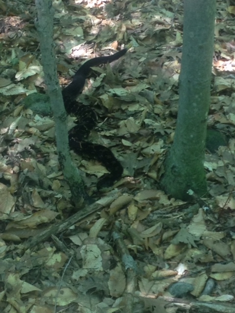
A rattlesnake on Montcalm point.

The following picture of a rattlesnake was sent to my by Neal Vandorsten who was taking a hike to Montcalm point on the western shore. “As we go closer to it, it coiled and rattled, so we quickly went on our way, and left it alone,” said Neal.

Wader Minute


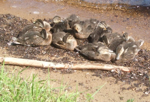
A mother duck and ducklings huddled together on the shoreline this morning.

I was out mowing this morning and came upon this scene along the shoreline.

Bits of Everything

Expanded Lake George Trail System Eyed

The Adirondack Almanack reports on the “Trails Master Plan” for the west shore of Lake George.

New Fishing Tournament for Lake George

Grab a fishing pole and maybe you can win $2,500 in grand prize money between Friday, July 10 to Sunday, July 12th. Read in the Lake George Mirror.

Cuomo’s Quiet Medicaid Miracle?

“New York still spends more on Medicaid than California and Texas combined.” Read the NY Daily News article.

NASA JPL: Heat-Converting Material Patents Licensed to Troy Company

The future is happening now. Read the JPL Press Release.

Adirondacks Burn Ban In Effect

With fire season upon us, Dresden is covered until May 14th. So says the Adirondack Almanack.

LGLC Secures Public Access to Anthony’s Nose


View of Anthony’s Nose on Lake George, NY.
Photo Credit: Carl Heilman, II/Wild Visions, Inc.

The Lake George Land Conservancy (LGLC) recently completed the purchase of more than 18 acres in the Town of Putnam (Washington County) that provides a point of public access to LGLC’s 189-acre Anthony’s Nose property.

LGLC purchased Anthony’s Nose, which includes Record Hill, in December of 2000. Home to nesting peregrine falcons, the property’s rocky cliffs are an iconic feature in northern Lake George. The land also includes 3,350 feet of lake shoreline, and abuts the 244-acre Flat Rock property to the north, part of the Adirondack Forest Preserve.

The newly acquired property consists of 15.5-acres adjoining the southeast edge of Anthony’s Nose, a 2.6-acre block on Schwerdtfeger Road, and a 50-foot easement of right-of-way connecting the two.

Already enjoyed by locals, the property’s half-mile hiking trail to the summit of Record Hill will be made official with LGLC blazes this spring, and a parking area on Schwerdtfeger Road will be constructed by the end of the summer. The preserve also will now be part of LGLC’s annual Hike-A-Thon, which is held each July 5th.

LGLC Executive Director Jamie Brown said, “This conservation project is a major accomplishment and I’m pleased that we are finally be able to offer Anthony’s Nose as a true public resource.”

A fundraising campaign is in progress to pay for the purchase, which was made possible thanks to a private loan and donations from individuals, families and foundations. LGLC recently received a $35,000 grant for this project from The Conservation Alliance, whose mission is to engage businesses to fund and partner with organizations to protect wild places for their habitat and recreation values. More information about the project and how to donate can be found at www.lglc.org/projects/anthonys-nose-access.

LGA’s Salmon in the Classroom Begins

Salmon eggs have new homes in the Lake George watershed! This is the 4th year that the Lake George Association will be assisting classes with the Salmon in the Classroom, a program created by Trout Unlimited.

Students at Ticonderoga Middle School, Whitehall High School, and Lake George Elementary will raise salmon from eggs to fingerlings while learning about fish life cycles, water quality, aquatic ecosystems, biodiversity, conservation, and sustainability.

Christmas Bird Count with the LGLC


A male goldfinch.

Christmas Bird Count
Saturday, December 20

Join this annual nation-wide citizens science effort to survey bird populations, locally organized by the Lake George Land Conservancy. Observe by car, foot, boat or at the feeder. Meet up with fellow CBC participants afterwards to compare counts while warming up with coffee and hot chocolate. Count circle includes Bolton, Diamond Point, Cleverdale, and east shore from Pilot Knob to Black Mt. Times vary. Free. Pre-registration required: email events@lglc.org or call 518-644-9673.

For more information about the Christmas Bird Count, visit http://birds.audubon.org/christmas-bird-count.

DEC seeks help for Moose sightings

The DEC staff from Region 5 are seeking the public’s assistance to locate moose for a moose population study. A moose was seen in Washington County last year (picture here).

If anyone sees a moose, please report it immediately to the DEC at 518-897-1291.

The DEC appreciates the public’s assistance to learn more about NY’s largest mammal.

Lake George Association Partners with Norowal Cabin Owners’ Association to Install Native Plant Shoreline Buffer


Looking out to Lake George from the Norowal Cabin Owners’ Association property in Bolton.

The Lake George Association has partnered with the Norowal Cabin Owners’ Association to install a native plant buffer along a section of the association’s shoreline along the Lake. In addition to wanting to buffer the shoreline to help protect the Lake from any potential stormwater runoff in the area, the association is also hoping that the buffer will help keep Canada geese off their property.

“We were very excited to partner with the homeowner’s association on this project. Complaints about Canada geese are nothing new around the Lake. In fact, earlier this summer we partnered with USDA/APHIS Wildlife Services to begin a Canada goose survey of the Lake as a first step in developing a management plan,” said Emily DeBolt, LGA’s Outreach Coordinator. “However, there are steps that property owners can take on their own as well,” said DeBolt.


A view in from the lake.

One such step is maintaining – or re-creating – a more natural shoreline. When geese have a direct line from the Lake to tasty, green grass, it is like an open invitation for them. “We can’t really blame the geese,” said DeBolt. “I know it isn’t what people want to hear, but we have created an ideal scenario for them and they are just obliging.”

Luckily, the homeowners at the Norowal Cabin Owners’ Association listened to what DeBolt had to say. The shoreline buffer installed at the Norowal Homeowner’s Association property will hopefully help with the goose problem come spring. By then, the native perennials installed this fall will be getting established, and will be tall enough to deter the geese, but not so tall as to impede the view of the Lake for the homeowners that use the property. “We were thrilled to work with the LGA staff to make this project happen,’ said Cheryl Lamb, Association member. “We have wanted to address our shoreline area for a while now, but we just weren’t sure where to begin. The LGA’s expertise made it possible. We can’t thank them enough for all their help.”


Native blue flag iris is planted on the left. Invasive yellow iris appears on the right.

Another important part of this project was first removing a large section of yellow iris that had taken hold along the shoreline. Yellow iris is an extremely invasive plant that is found along the shorelines of the Lake. The seeds float, so the water carries them, allowing the plant to pop up anywhere the wind takes it. “What was interesting about this yellow iris was that on the same section of shoreline there was also the native blue flag iris as well just a few feet away. You could really tell the difference between the two in terms of size when they were next to each other like that. We were sure to remove the invasive yellow iris but keep the native blue flag iris as part of the new buffer,” said DeBolt. “We will be sure to monitor the planting next year to see if any bits of yellow iris pop back up as well. We did our best to remove it all, but it is always a good idea to monitor an area for a few years just to make sure you got it all.”

“This buffer had many different components to it that will benefit the Lake. We were able to not only remove invasive species, but also then plant native species to both better stabilize the shoreline to prevent erosion and provide a buffer before stormwater runoff reaches the lake. And as if all that wasn’t enough, it will also discourage geese from using the area,” said DeBolt. “We really wish everyone would consider buffering their shoreline with native plants. It’s not only an investment in your property, but it’s also an investment in the Lake. We can’t think of a better win-win than that.”