
Bolton Repaving and Stormwater Project – Update and Scope.
By Randy Rath, Lake George Association Project Manager
Two weeks ago, the Lake George Association (LGA) asked for a tour of the New York State Department of Transportation (DOT) project taking place on Route 9N in Bolton. Pat Kemble, one of the designers, was able to talk about and show us some of the work that has been taking place.
The project was originally proposed as a standard repaving project, but the DOT has taken the opportunity to add significant stormwater infrastructure and replace older stormwater systems. The Route 9N repaving project is estimated to cost over $3 million when all is completed. The greatest benefit to Lake George is the recognition that stormwater needed to be better managed. DOT deserves a big thumbs up.
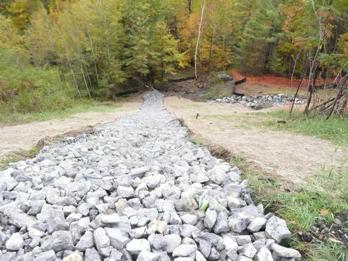
Stormwater retrofits were started just after Labor Day near the intersection of County Route 11. Stormwater trenches that run parallel to County Route 11 and carry water most of the year were the first to be tackled. At the end of County Route 11 both trenches carry water under Route 9N toward Lake George. Both of those culverts have been replaced with smooth bore culverts. The entire area around the south entrance has been stabilized with the stormwater now directed into a smooth bore culvert that has a flared entrance. The flared entrance and smooth bore culverts allow for greater flow of stormwater during peak storm events. On the backside of the hill, where the culverts release the water, both areas have been lined heavily with rip rap to armor the area and protect against erosion. It also helps to slow down the stormwater.
At the very end of Co. Rt. 11, along the guardrail of Rt. 9N, there are several drop inlets with small sumps to capture any sand or debris from the road. The inlets drop water off the backside of the hill onto “gabions” or baskets of stone that run from the top to the bottom of the hill. The gabions consist of stone rip rap that has been placed in wire baskets. The gabions will keep their form and not roll downhill over time. They will also slow the stormwater down allowing it to infiltrate into the ground.
Further south down 9N toward the center of town, DOT is placing additional stormwater upgrades near the RPI Darrin Fresh Water Institute. Several catch basins with sumps to allow for settling of solids will be placed above Finkle Brook. These should capture most of the sediment coming from the road and help to slow future growth of the delta which has formed at the mouth of the brook.
New infrastructure continues along 9N from the Veteran’s Park entrance to Sagamore Road on both sides of the road. New catch basins have been installed and a few culverts have been replaced. Sidewalks on the east side of the road will now continue up to the Veteran’s Park entrance. Across the street from the school fields, DOT purchased a small section of property in order to place an oversized culvert that will handle the runoff coming from the area around the intersection of Sagamore Road and Route 9N.
The next area to receive an upgrade is near the Lake George Land Conservancy parking lot. Two larger catch basins with sump areas were placed on either side of Rt. 9N. These replace catch basins that were too small and relatively ineffective. The new basins actually tie back into the culvert that brings Stewart Brook under the parking lot instead of flowing east and dropping out into Stewart Brook.
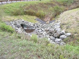
The project nears its end, and one of its most difficult challenges dealing with stormwater, just south the Saint Sacrament Church. At this location, there is stormwater coming from the north and south with additional stormwater coming down off of Mohican Road. Prior to the project’s inception, stormwater would enter drop inlets on either side of the road and exit directly to the lake via a culvert that runs under the Miller property exiting at Bixby Beach. In 2008, the LGA and Town funded a project to control stormwater on Bixby Beach. Warren County Soil and Water Conservation District (WCSWCD) planned and oversaw the work completed by the Town Highway Department. In preparation for that project, DOT was consulted to determine if the projects could be combined. It was determined that the projects would not be running concurrently, so we moved ahead with the Bixby project.
As part of the new project, DOT has plugged the culvert that runs through the Miller property and has directed the stormwater to Bixby Road. Prior to the stormwater entering the culvert it runs through a system of catch basins and dry wells: one set in both the north and south directions on the east side. The dry wells were added to see if some of the stormwater could be infiltrated into the ground rather than flow directly to the lake. They will also help with allowing sand and debris to drop out of the water before it enters the culvert. The outflow to the lake runs along the south side of Bixby Road. It brings the 2008 project outflow from the north side over to the south side so that there is only one outflow pipe.
The dry wells that were installed by DOT are going to be interesting to monitor as DOT has not previously used the structures and has been reluctant to permit their use along state roads. We hope it is successful, as it will more beneficial to the lake to get stormwater into the ground, rather than bringing it directly to the lake.
The sidewalk has been extended down to the entrance of Bixby Road and the vegetation that was removed will be replaced with native shrubs and trees. The project is wrapping for the 2009 construction year. There are just a few stormwater structures to be placed before they pave and seed for the winter. The schedule calls for the remainder of the project to be completed in the spring with a finish date well before the summer crowds arrive.
The DOT crews are staying on schedule and doing an excellent job. We appreciate all of the extra stormwater measures they have put in place to protect our beautiful natural resource.